- About Us
- Committees
- SUT Houston Branch Executive Committee
- Offshore Site Investigation and Geotechnics (OSIG)
- Subsea Engineering and Operations - Atlantic (SEO-Atlantic)
- Group on Environmental Forces (GEF)
- Robotics & Automation (R&A)
- Marine Renewable Energy Committee (MREC)
- Education Committee
- SUT Young Professionals
- Advisory Committee
- School Touring Committee
- Women in Industry
- Become a Member
- Student Chapters
- Mentoring Program
- Learning Programs
- Events
- News
- 2023
- 2022
- 2021
- 2020
- SUT-US Champagne & Conversation Series Edition 5
- SUT-US Makes Its 15th Appearance at Subsea Tieback Forum & Exhibition
- SUT-US Brings Its School Touring Program to the Largest School District in Houston
- SUT-US Brings Its School Touring Program to the Largest School District in Houston
- SUT-US Champagne & Conversation Series Edition 6
- Making History - SUT-US Elects its First Woman Chair and President
- Scholarship Awards Ceremony 2020
- 2019
- 2018
- 2017
- Dr. Medina-Cetina Presents at European Geosciences Union (EGU) GIFT Workshop
- 'Geology Rocks' 500 at Thornton Middle School
- SUT-SEO Presents Subsea Awareness Course
- Society for Underwater Technology Awards Six at Scholarship Reception
- School Touring Reaches Opal Hamilton Students
- Passion Runs Deep in the Subsea Engineering Society
- Galveston Student Chapter Presents First Short Course
- Promoting A Welcoming Environment, SUT Actively Combats Discrimination and Sexual Harassment
- Subsea Awareness Course Offer its Expertise to Mexico's Industry Professionals
- SUT-US Gifts this Academic Year's Annual Sponsorship Checks to its Student Chapters
- SUT-USA Launched the New Committee: Group on Environmental Forces
- SUT-US Launches a New Student Chapter at Rice University
- 2017-2018 Scholarship Awards Ceremony
- 2016
- Press Releases
- Subscribe
Geomagnetic Storms in Marine Magnetometer Data at Low Latitudes
Starts: Thu, Jun 22, 2017 8:00 AM CSTEnds: Thu, Jun 22, 2017 9:00 AM CST
Become a Member Now
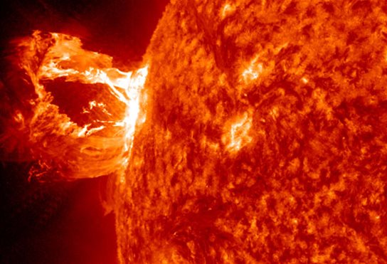
An eruption on April 16, 2012, captured by NASA's Solar Dynamics Observatory in the 304 Angstrom wavelength, which is typically colored in red.
Credit: NASA/SDO/AIA.
Webinar-Only Event
8:00am CDT
9:00am EDT
Cost
Members $25
Non-members $30
Please note that the registration cost includes one certificate per registration. A $10 fee applies per additional certificates for multiple attendees at one single location.
Abstract
In 2016, the authors published evidence demonstrating that strong magnetic field perturbations resulting from Earth-directed solar events can adversely affect marine archaeological survey. Based on a 95% confidence level, it was estimated that 89.7 to 100 percent of geomagnetic storms occurring on days of Kp 5 1 or greater will generate marine magnetometer signatures that may be misinterpreted as archaeological sites. Aggressive processing, analysis, and comparison of single instrument, total field marine magnetometer datasets were unable to isolate and remove the storm sudden onset signature. These findings, however, only demonstrated the phenomena in data collected at mid-latitudes (Carrier et al. 2016).
This paper builds on that work by presenting analysis of additional survey data collected from a low latitude region in the Gulf of Mexico. Although it is understood that geomagnetic storms affect Earth’s magnetic field to a greater degree at high latitudes – that is, near the poles – and to a lesser degree at low latitudes – closer to the equator – the prevailing assumption that geomagnetic storms are not a problem in the Gulf of Mexico is unsubstantiated by the empirical evidence. Observatory datasets analyzed in this paper plainly reveal that geomagnetic storms affect Earth’s magnetic field at low latitudes and external source artifacts remain in professionally-collected survey data, even after aggressive processing. Recommendations are made for marine magnetic data collection and processing methods that adequately account for geomagnetic storms, allowing for improved precision in analytical interpretation and thus improved identification of archaeological resources.
About the Presenter

Brandi Carrier is a Registered Professional Archaeologist and scientific diver with nearly twenty years of experience in cultural resources management and an MA in Archaeology and Prehistory. She joined the Bureau of Ocean Energy Management in 2011 to provide regulatory support for the nation's development of offshore renewable energy.
In her present role as BOEM’s Deputy Preservation Officer, Brandi serves as the Bureau's authority on historic preservation matters, and develops national policy on submerged underwater cultural resource preservation. In addition, Brandi designs, directs, and conducts marine archaeological research in support of responsible energy development. When Brandi isn’t diving, running, or sailing, she’s hiking the trails with her husband Mike and their border collie Mattie.
1 Kp refers to Kp index, or Planetarische Kennziffer, a value that measures the three-hour magnetic field variation from thirteen sub-auroral magnetic observatories around the world on a quasi-logarithmic scale from 0–9 (Maus et al 2010); the greater the Kp, the more perturbed Earth’s magnetic field.
Brandi Carrier is a Registered Professional Archaeologist and scientific diver with nearly twenty years of experience in cultural resources management and an MA in Archaeology and Prehistory. She joined the Bureau of Ocean Energy Management in 2011 to provide regulatory support for the nation's development of offshore renewable energy.
In her present role as BOEM’s Deputy Preservation Officer, Brandi serves as the Bureau's authority on historic preservation matters, and develops national policy on submerged underwater cultural resource preservation. In addition, Brandi designs, directs, and conducts marine archaeological research in support of responsible energy development. When Brandi isn’t diving, running, or sailing, she’s hiking the trails with her husband Mike and their border collie Mattie.
File Attachments
Donate to SUT
 Add this Event to your
Outlook Calendar
Tickets
Webinar
Available Online Only
$25.00 Members Webinar
$30.00 Non-Members Webinar
FREE Student Members Webinar
FREE Student Non-Members Webinar
Add this Event to yourOutlook Calendar
June 2017


