- About Us
- Committees
- SUT Houston Branch Executive Committee
- Offshore Site Investigation and Geotechnics (OSIG)
- Subsea Engineering and Operations - Atlantic (SEO-Atlantic)
- Group on Environmental Forces (GEF)
- Robotics & Automation (R&A)
- Marine Renewable Energy Committee (MREC)
- Education Committee
- SUT Young Professionals
- Advisory Committee
- School Touring Committee
- Women in Industry
- Become a Member
- Student Chapters
- Mentoring Program
- Learning Programs
- Events
- News
- 2023
- 2022
- 2021
- 2020
- SUT-US Champagne & Conversation Series Edition 5
- SUT-US Makes Its 15th Appearance at Subsea Tieback Forum & Exhibition
- SUT-US Brings Its School Touring Program to the Largest School District in Houston
- SUT-US Brings Its School Touring Program to the Largest School District in Houston
- SUT-US Champagne & Conversation Series Edition 6
- Making History - SUT-US Elects its First Woman Chair and President
- Scholarship Awards Ceremony 2020
- 2019
- 2018
- 2017
- Dr. Medina-Cetina Presents at European Geosciences Union (EGU) GIFT Workshop
- 'Geology Rocks' 500 at Thornton Middle School
- SUT-SEO Presents Subsea Awareness Course
- Society for Underwater Technology Awards Six at Scholarship Reception
- School Touring Reaches Opal Hamilton Students
- Passion Runs Deep in the Subsea Engineering Society
- Galveston Student Chapter Presents First Short Course
- Promoting A Welcoming Environment, SUT Actively Combats Discrimination and Sexual Harassment
- Subsea Awareness Course Offer its Expertise to Mexico's Industry Professionals
- SUT-US Gifts this Academic Year's Annual Sponsorship Checks to its Student Chapters
- SUT-USA Launched the New Committee: Group on Environmental Forces
- SUT-US Launches a New Student Chapter at Rice University
- 2017-2018 Scholarship Awards Ceremony
- 2016
- Press Releases
- Subscribe
Register NOW for this Thursday's SUT Webinar and Learning Luncheon: "Overview of the NOAA Ocean Exploration and Research Program and Recent Okeanos Explorer Expeditions"
Starts: Thu, Jun 4, 2015 11:30 AM CSTEnds: Thu, Jun 4, 2015 1:00 PM CST
Become a Member Now
SUT Webinar and Learning Luncheon!
SUT Houston's Offshore Site Investigation and Geotechnics Committee Presents:
"Overview of the NOAA Ocean Exploration and Research Program
and Recent Okeanos Explorer Expeditions"
Presented by: Meme Lobecker – Physical Scientist/Hydrographer, NOAA Office of Ocean Exploration and Research
SUT Houston's Offshore Site Investigation and Geotechnics Committee Presents:
"Overview of the NOAA Ocean Exploration and Research Program
and Recent Okeanos Explorer Expeditions"
Presented by: Meme Lobecker – Physical Scientist/Hydrographer, NOAA Office of Ocean Exploration and Research
Thursday, June 4th
11:30 a.m. - 1:00 p.m. CDT
Lunch will be served at 11:30 a.m.
Presentation/webinar will begin at 12:00 p.m.
Norris Conference Center - WESTCHASE
9990 Richmond Ave. Suite #102
Houston, TX 77042
(713) 780 - 9300
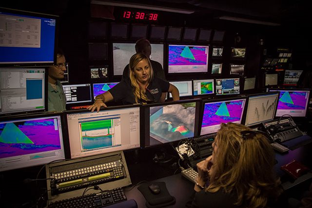
Meme Lobecker in the control room of the NOAA Okeanos Explorer
Biography:
Meme has spent fifteen years in the environmental field, thirteen of which have directly related to seafloor mapping and the marine sciences. She holds an MA in Marine Affairs from the University of Rhode Island and a BA in Environmental Studies from George Washington University. As Senior Mapping Team Lead, she is in charge of the various seafloor mapping systems onboard the NOAA Ship Okeanos Explorer. During an exploration cruise, Meme is responsible for all mapping data collected, and produces the maps that are required for the exploration process to proceed to the level of ROV exploration. When not at sea mapping, Meme works on the post processing and archiving of data, plans upcoming cruises, and represents NOAA OER at scientific conferences and meetings throughout the year. She is based at the Integrated Ocean and Coastal Mapping Center at the University of New Hampshire. Prior to working with NOAA, she was an independent contractor for the international seabed cable and offshore energy industries. Her work in that arena took her to the North Sea, the Mediterranean, the Western Pacific and the Eastern Atlantic. She began her offshore career working with SAIC conducting shallow water mapping for nautical chart updating in New England and the Gulf of Mexico.
Abstract:
NOAA Ship Okeanos Explorer, “America’s Ship for Ocean Exploration,” is the only federally funded U.S. ship assigned to systematically explore our largely unknown ocean for the purpose of discovery and the advancement of knowledge.Telepresence, using real-time broadband satellite communications, connects the ship and its discoveries live with audiences ashore. Our unique capabilities allow us to reduce unknowns in deep-ocean areas and provide the high-value environmental intelligence needed by NOAA and the nation to address both current and emerging science and management needs. Since the ship was commissioned on August 13, 2008, the Okeanos Explorer has traveled the globe, exploring the Indonesian ‘Coral Triangle Region;’ benthic environments in the Galápagos; the geology, marine life, and hydrothermal systems of the Mid-Cayman Rise within the Caribbean Sea; and deep-sea habitats and marine life in the northern Gulf of Mexico and US East Coast including several Atlantic canyons and New England Seamount chain. OER provides partnership coordination, funding, staff, tools, and expertise needed to develop exploration missions that deliver rigorous, systematic observations and documentation of biological, chemical, physical, geological, and archaeological aspects of the ocean. OER works to get scientists to uncharted areas; to design, test, and implement new deep-sea technologies; and to bring the wonders of ocean exploration to everyone. And, during and after expeditions, OER's system of data management ensures that collected information arrives quickly – and accurately – into the hands of those who need it to make timely decisions.
Meme will present on NOAA's Okeanos Explorer program, particularly the mapping capabilities of the ship, and will provide insights into the recent discoveries made in the Gulf of Mexico, including gaseous seeps, salt domes, asphalt extrusions, and deep sea coral communities.
Society for Underwater Technology - This multi-disciplinary learned society brings together organizations and individuals with common interests in underwater technology, ocean science and offshore engineering. The SUT was founded in 1966 in London and has members from more than 40 countries including engineers, scientists, other professionals and students working in these areas.
The SUT was founded to promote the further understanding of the underwater environment to encourage cross fertilization and dissemination of ideas, experience and information between workers in academic research, applied research and technology, industry and government development of techniques and tools to explore and study oceans, proper economic and sociological use of our resources in and beneath the oceans, further education of scientists and technologists to maintain high standards in marine science and technology
The SUT was founded to promote the further understanding of the underwater environment to encourage cross fertilization and dissemination of ideas, experience and information between workers in academic research, applied research and technology, industry and government development of techniques and tools to explore and study oceans, proper economic and sociological use of our resources in and beneath the oceans, further education of scientists and technologists to maintain high standards in marine science and technology
Donate to SUT
 Add this Event to your
Outlook Calendar

Houston, TX 77042, USA
Phone: 713-780-9300
Website: http://www.norriscenters.com/HoustonWC/
Tickets
50 Seats Event Capacity
$35.00 Members Tickets
$40.00 Non-Members Tickets
FREE Student Members
FREE Student Non-Members
Webinar
Available Online Only
$30.00 Members Webinar
$35.00 Non-Members Webinar
FREE Student Members Webinar
FREE Student Non-Members Webinar
Add this Event to yourOutlook Calendar
June 2015
Event Location
Norris Conference Center - Westchase
9990 Richmond AvenueHouston, TX 77042, USA
Phone: 713-780-9300
Website: http://www.norriscenters.com/HoustonWC/


